We left By the Lake RV Park around 9:00 and continued on I-35 through Dallas, TX and into Austin. I-35 is an interesting road - it actually splits north of Dallas. I-35W goes to the west of the city; I-35E goes to the east of the city. We took I-35W, past the Dallas skyline and then onward through Waco and into Austin. It was a long day and we hit Austin during the afternoon rush. Our GPS took us on a round-a-bout path over the so called MOPAC.
Now, arriving at Em's brothers was a challenge for a 30-foot long, 13-foot high vehicle. He lives in the city - a residential part of the city with beautiful Oak trees and low overpasses. We had to avoid one low railroad bridge and find an alternate route. That bridge was marked as 13' 7"; just too close to our height for comfort. And those beautiful trees were not trimmed for tall vehicles, so we found ourselves in the middle of the road quite often to avoid low-hanging branches. Thankfully, those branches were pliable so even when we brushed them, there was no damage. Traffic was sparse on these city streets.
We parked the rig in front of Brother's house - expecting the ground to be level. The crown on the road was so high, our leveling jacks raised the curb side wheels about 5" off the ground. So we abandoned all attempts to level off, turned off the fridge and took the food into the house.
Our two-day visit was wonderful. We sat and talked, toured the state capitol building and drove through a lot of the city, had a nice lunch at The Oasis, a restaurant high on a hill overlooking a beautiful lake. On Saturday, we started slow, and were joined by Brother's friend K and her parents for a nice lunch at Matties at Green Pastures which was the former home of talk show host John Henry Faulk who successfully sued the entertainment industry to halt the use of the Holywood Blacklist. It was a delicious meal.
We continued our visiting into the evening and made preparations for our departure on Sunday morning. It was hot and humid with temps in the high 90's. So the RV was toasty warm even with the Fantastik fans pulling the hot air out through the roof vents.
We pulled away around 8:30 and headed back north on I-35, this time taking the I-35E branch and then turned east toward home. We stopped for the night at another lovely campground called simply Dallas NE Campground in Caddo Mills, TX about 60 miles east of Dallas. Tomorrow we head back into Arkansas to pick up I-40 east through Tennessee and into Virginia. Planned arrival at the homestead is Sunday afternoon, July 17.
Sunday, July 9, 2017

Wednesday, July 5, 2017
More about Lyons and Central Kansas
Our visit with my sister, sadly, had to end today (Wednesday, July 5). We headed south, eventually getting onto I-35 through Wichita and Oklahoma City. In our trek today, we actually crossed our west-bound path on I-40, but continued south toward Dallas, Texas. Tonight we are camping in a beautiful new campground: By The Lake RV Park, in Ardmore, OK. It's not crowded, has nice wide sites with paved roads and concrete pads. There is a small lake for fishing, a pool, and lots of sunshine (very few trees, all newly planted).
I would like to say a little more about Lyons. This is a great example of small-town America. Everyone knows everyone and greets their neighbors with a smile or friendly wave. For the weekend, there was a classic car exhibit at the town square, and fireworks on Tuesday night. The gathering place in town is the local Dairy Queen. We went there Sunday morning for breakfast, and again on Monday morning for coffee. Conversations among the locals centered on farm life topics like the price of wheat, and stories about equipment repairs and of course the recently completed harvest.
I mentioned the other day that the main product from this area is grain. But there is another important resource: energy. There is oil and natural gas under those wheat fields. So, many of the towns have petroleum processing plants or host interstate pipelines, and their management, that ship oil, gas, propane, and other energy products across the country. We saw ethanol plants too that take advantage of the corn and milo grown locally. Also beneath those fields of grain lies salt. Salt mining is another business there and Lyons has a salt processing plant. When the salt has been removed from under ground, a cavern remains. Those caverns become storage vaults for the energy products - kept there until its needed to heat our homes and power our autos.
We spent time visiting with my sister and her husband of course. But also took a few trips into the towns for errands, supplies and some sightseeing. We had a tour of Lyons and drove to Hutchinson where we visited the Cosmosphere - a state-of-the-art museum devoted to the history of space travel from World War II to the present day. They had numerous artifacts including actual V-1 and V-2 rockets, a SR-71, the Space Shuttle Endeavor and the Apollo 13 capsule.
Tomorrow, we continue into Texas, destination Austin, to visit Em's brother. From there we head for home, planning to take our time and enjoy a few more nights camping.
I would like to say a little more about Lyons. This is a great example of small-town America. Everyone knows everyone and greets their neighbors with a smile or friendly wave. For the weekend, there was a classic car exhibit at the town square, and fireworks on Tuesday night. The gathering place in town is the local Dairy Queen. We went there Sunday morning for breakfast, and again on Monday morning for coffee. Conversations among the locals centered on farm life topics like the price of wheat, and stories about equipment repairs and of course the recently completed harvest.
I mentioned the other day that the main product from this area is grain. But there is another important resource: energy. There is oil and natural gas under those wheat fields. So, many of the towns have petroleum processing plants or host interstate pipelines, and their management, that ship oil, gas, propane, and other energy products across the country. We saw ethanol plants too that take advantage of the corn and milo grown locally. Also beneath those fields of grain lies salt. Salt mining is another business there and Lyons has a salt processing plant. When the salt has been removed from under ground, a cavern remains. Those caverns become storage vaults for the energy products - kept there until its needed to heat our homes and power our autos.
We spent time visiting with my sister and her husband of course. But also took a few trips into the towns for errands, supplies and some sightseeing. We had a tour of Lyons and drove to Hutchinson where we visited the Cosmosphere - a state-of-the-art museum devoted to the history of space travel from World War II to the present day. They had numerous artifacts including actual V-1 and V-2 rockets, a SR-71, the Space Shuttle Endeavor and the Apollo 13 capsule.
Tomorrow, we continue into Texas, destination Austin, to visit Em's brother. From there we head for home, planning to take our time and enjoy a few more nights camping.
Saturday, July 1, 2017
Lyons Kansas
We left St Joseph's MO on Friday and headed back to the west on the Lewis and Clark Trail to pick up I-70 west. We passed through the beautiful Flint Hills which is some of the most fertile pasture land in the USA. Cattle ranchers from Texas would drive their herds to the Flint Hills to fatten them for sale at the exchanges in Kansas City. At Ellsworth we headed south into Lyons to visit my sister and brother-in-law for a few days. We plan to spend the 4th here before continuing south to Austin, TX.
On Saturday, we took a walking and driving tour of the town of Lyons, and had a nice dinner at the Lone Wolf Restaurant in Elinswood. Lyons is basically a farm town where the main product is grain: wheat, corn, milo (sorghum) and soy beans. The winter wheat harvest just concluded last week. The corn, milo and beans are growing well for harvest in the fall.
On Saturday, we took a walking and driving tour of the town of Lyons, and had a nice dinner at the Lone Wolf Restaurant in Elinswood. Lyons is basically a farm town where the main product is grain: wheat, corn, milo (sorghum) and soy beans. The winter wheat harvest just concluded last week. The corn, milo and beans are growing well for harvest in the fall.
Wednesday, June 28, 2017
Missouri Star Quilt Company Hamilton, MO
We left Ay and Em's house on Sunday heading across Colorado and then northern Kansas to St. Joseph Missouri. Driving across Kansas on US Route 36, "The Pony Express Highway", the landscape made a radical change as did the elevation. Colorado and western Kansas was pretty barren - high desert, dry and lacking a lot of green vegetation and trees. As we continued east, though, we descended about 2000 feet in elevation. By the time we got into eastern Kansas, the fields were green and there were lots of trees. Another observation: one may think of Kansas as relatively flat. NOT!!! At least the northern part along US 36 had lots of rolling hills. It was quite a change from the mountains of Colorado and the mesas and buttes of Arizona and Utah.
We stopped about two hours into the state of Kansas at the Prairie Dog State Park near Norton, KS. This was a beautiful location - no prairie dogs seen, but the campground was on a large reservoir, was well-maintained, and quiet. It was a nice break to relax and enjoy some leisure time.
We left Prairie Dog on Monday morning, continuing across US 36 into Missouri, crossing the Missouri River around 3:30 PM. We arrived at the AOK RV Park outside St Joseph shortly thereafter. AOK is a family-owned and operated Good Sam Park, sitting on a small lake with lots of grass. The RV pads and roads are gravel. We were concerned as we turned off the highway as the entry road was also gravel and the campground sign was a bit faded, so we were not sure we were turning at the right place. A phone call to the campground alleviated our concern and we proceeded down the hill and into the AOK. The staff has been wonderful, even personally guiding us into our campsite. The sites are configured so that two RVs sit utility side to utility side. We share the electrical pedestal and water connection and each have a separate sewer fitting. The upside of this is a larger "front" yard with grass and a picnic table. The downside is that our slide and the slide of our neighbor are just a few feet apart. Our elevation has decreased some more to just under 1,000 feet. We can breathe again.
On Tuesday we picked up a rental car and did some grocery shopping. Then we relaxed in camp until dinner. On Wednesday, June 28 we headed east on US 36 to Hamilton, MO. This is the home of the Missouri Star Quilt Company and the boyhood home of J. C. Penney. There are 12 quilt shops that are part of "Star", all on the main street of Hamilton. Each shop contains a different style of fabric: vintage, seasonal, batiks, etc. One of the shops is in the location of the first J. C. Penney department store. We spent about 5 hours walking through the shops and looking for fabric for a quilting project Em is going to do where we get home.
Thursday will be another "in camp" day - we need to do some housekeeping and prepare for the next phase of our adventure. On Friday, we head back into Kansas to visit El's sister and her husband. We'll be there through July 4.
We stopped about two hours into the state of Kansas at the Prairie Dog State Park near Norton, KS. This was a beautiful location - no prairie dogs seen, but the campground was on a large reservoir, was well-maintained, and quiet. It was a nice break to relax and enjoy some leisure time.
We left Prairie Dog on Monday morning, continuing across US 36 into Missouri, crossing the Missouri River around 3:30 PM. We arrived at the AOK RV Park outside St Joseph shortly thereafter. AOK is a family-owned and operated Good Sam Park, sitting on a small lake with lots of grass. The RV pads and roads are gravel. We were concerned as we turned off the highway as the entry road was also gravel and the campground sign was a bit faded, so we were not sure we were turning at the right place. A phone call to the campground alleviated our concern and we proceeded down the hill and into the AOK. The staff has been wonderful, even personally guiding us into our campsite. The sites are configured so that two RVs sit utility side to utility side. We share the electrical pedestal and water connection and each have a separate sewer fitting. The upside of this is a larger "front" yard with grass and a picnic table. The downside is that our slide and the slide of our neighbor are just a few feet apart. Our elevation has decreased some more to just under 1,000 feet. We can breathe again.
On Tuesday we picked up a rental car and did some grocery shopping. Then we relaxed in camp until dinner. On Wednesday, June 28 we headed east on US 36 to Hamilton, MO. This is the home of the Missouri Star Quilt Company and the boyhood home of J. C. Penney. There are 12 quilt shops that are part of "Star", all on the main street of Hamilton. Each shop contains a different style of fabric: vintage, seasonal, batiks, etc. One of the shops is in the location of the first J. C. Penney department store. We spent about 5 hours walking through the shops and looking for fabric for a quilting project Em is going to do where we get home.
Thursday will be another "in camp" day - we need to do some housekeeping and prepare for the next phase of our adventure. On Friday, we head back into Kansas to visit El's sister and her husband. We'll be there through July 4.
Sunday, June 25, 2017
Rocky Mountain National Park
Our next stop was at our friends Ay and Em's home in Lafayette, CO. We broke the trip into two short-drive days, stopping in a small town in Silt, Colorado en route. We stayed at the Silt/Colorado River KOA - right off I-70 and in a valley with the river running just a few yards from the campground. This was a beautiful spot and an extremely nice (albeit young) campground. The youthfulness of the facility meant that the trees were small and did not offer a lot of shade. But, the proximity of the river, cleanliness of the facility and friendliness of the staff made up for that. Temperatures were in the 90's on arrival and our A/C had difficulty cooling down our rig once we had everything connected. We made use of the nice laundry facility and ordered pizza for dinner from a local pizzeria. It was good.
During our stay we say a lone elk on the opposite bank of the river, grazing on the vegetation and drinking from the swift-running water of the Colorado. Later, we saw a lone bald eagle perched in a dead tree, also on the opposite side of the river. I've provided some photos of the elk and eagle. As darkness set in, we took a look a the sky and were wowed by the clarity and number of stars visible. I've been wanting to get a photo of the Milky Way and thought this might be a good opportunity. Photo provided below - it was amazing!!!
We left at a reasonable hour the next morning for the 4-hour drive into Lafayette. I-70 passes through amazingly beautiful canyons along the Colorado River before climbing through 10,000 feet over the Continental Divide. Our RV had some trouble climbing these steep hills - but we made it over the Rockies, through Denver and Boulder and into Lafayette. On Friday, Al and El made the drive through Estes Park to Rocky Mountain National Park, the second most-visited national park in the US (the most visited park is Great Smokey Mountains NP). RMNP was gorgeous - rugged, wild, and beautiful. Photos follow.

 This is my first attempt at astrophotography. Conditions were not ideal as you can see the affects of lights from the town of Silk in the lower left corner of the photo. But, otherwise, the Milky Way shows nicely in the rest of the photo.


During our stay we say a lone elk on the opposite bank of the river, grazing on the vegetation and drinking from the swift-running water of the Colorado. Later, we saw a lone bald eagle perched in a dead tree, also on the opposite side of the river. I've provided some photos of the elk and eagle. As darkness set in, we took a look a the sky and were wowed by the clarity and number of stars visible. I've been wanting to get a photo of the Milky Way and thought this might be a good opportunity. Photo provided below - it was amazing!!!
We left at a reasonable hour the next morning for the 4-hour drive into Lafayette. I-70 passes through amazingly beautiful canyons along the Colorado River before climbing through 10,000 feet over the Continental Divide. Our RV had some trouble climbing these steep hills - but we made it over the Rockies, through Denver and Boulder and into Lafayette. On Friday, Al and El made the drive through Estes Park to Rocky Mountain National Park, the second most-visited national park in the US (the most visited park is Great Smokey Mountains NP). RMNP was gorgeous - rugged, wild, and beautiful. Photos follow.


Thursday, June 22, 2017
Arches National Park - Last day in Moab, UT
Tuesday, June 20 was our final day in Moab, UT. The temperature rose to 104 to 110 degrees, depending on location in the park. But that did not deter us - we were determined to see as many arches and features in the park as we could in our single day there. We walked the trails (very little was viewable from the auto-accessible overlooks) for a total of over 5 miles to get a glimpse of these marvels of nature. We were awed. See the photos below for a short tour of this magical place.
On Wednesday, we continue east into Colorado planning to pause in Silt on the Colorado River.
Now that we have left our Moab campgound, I can feel free to say a few things about it. We camped in Canyonlands RV Park on the south end of town. It was very convenient to many services including groceries and restaurants. But, the campground itself was not quite what we had grown used to during this trip. We have stayed in several Good Sam and KOA properties and never have we felt so crowded and jammed in as in Canyonlands. While the park was well-treed with considerable shade (welcomed in the desert heat), the sites were narrow and short. The original site we were assigned was right next to the bathroom. OK - we can deal with that. But the six foot tall steel post installed to protect the bathroom (on the right of the site) and the tree on the left of the site, made it impossible to turn our 30-foot vehicle safely onto the pad. We were going to hit the post. So, we asked for another site and received one, reluctantly after a "we have a situation" call to the manager or owner of the campground. At the end of the road we had to drive down to get re-positioned for the new site was the dump station. If there is a RV at the dump site, other traffic through that area had to wait or risk damaging their rig on one of the large trees or worse on another RV. Our alternate site (and many others) was designated for a 40 to 45 foot RV. The pad was not long enough for all four wheels of our 30-foot vehicle to be on it. 2 were on concrete and 2 were on gravel. The "porch" portion of the pad had huge cracks in it. The "front yard" was just a bit wider than the picnic table. Setting aside the quality of the site, we were dismayed at the continued disregard for campground rules. Vehicles were parked in vacant sites, as well as in the road, making passage by large vehicles difficult. I'm surprised there weren't multiple accidents. All of the roads were two-way. Some sites had multiple vehicles - trailer, ATV and pick up truck. It looked like chaos. At least the bathrooms were clean; but they were a little outdated and small. One evening when we returned from our day of touring, there was a long line of vehicles waiting to get in the park making passage by our rental car impossible. The entrance was only wide enough for one vehicle to pass through - and there was very limited space at the registration office for vehicles to park. No one could get out either. The staff was friendly. Sorry to spend so much time on this - but given this was the highest-priced of our campgrounds so far, it was by far the most disappointing. There simply was not enough room for comfortable maneuvering and parking of large vehicles. Our recommendation is that anyone with a vehicle longer than 26 feet should choose another location.
Before we get to Arches - here are some photos from the campground. The building on the right is the bathroom, note the vehicle parked in the site. Also note the tall post that made a right turn with a long vehicle impossible.


Arches National Park: The "Park Avenue"


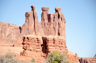
This formation is named "The Three Gossips". Cute.
 This photo shows an overview of the petrified sand dunes. Sand was covered in a concrete-like layer and compressed into rock. Then the concrete layer eroded away, leaving the petrified dunes.
 Double arch was spectacular. It was impossible to get photos of these formations without people milling around - but the people provide a size reference. These arches were huge.
 The next arch is called "North Window". Around the corner was "South Window".

 Near the two windows was "Turret Arch".
 This is the famous "Balanced Rock". The large boulder on top is harder than the underlying supporting rock. Unfortunately, the support is eroding away so eventually, Balanced Rock will come crashing down.

 The home on "Wolfe Ranch". Established by John Wesley Wolfe in the late 1800's.
 Petroglyphs near the Wolfe Ranch.
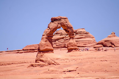
 Delicate arch was reachable only after a 3-mile hike along a rugged trail. Instead, we walked to the upper overlook and viewed it from afar. Again, people in the scene provide a perspective of size.
 The last arch we saw was "Skyline Arch".
 Finally, we visited "Devil's Garden" - a dramatic series of rock sculptures carved by nature.


On Wednesday, we continue east into Colorado planning to pause in Silt on the Colorado River.
Now that we have left our Moab campgound, I can feel free to say a few things about it. We camped in Canyonlands RV Park on the south end of town. It was very convenient to many services including groceries and restaurants. But, the campground itself was not quite what we had grown used to during this trip. We have stayed in several Good Sam and KOA properties and never have we felt so crowded and jammed in as in Canyonlands. While the park was well-treed with considerable shade (welcomed in the desert heat), the sites were narrow and short. The original site we were assigned was right next to the bathroom. OK - we can deal with that. But the six foot tall steel post installed to protect the bathroom (on the right of the site) and the tree on the left of the site, made it impossible to turn our 30-foot vehicle safely onto the pad. We were going to hit the post. So, we asked for another site and received one, reluctantly after a "we have a situation" call to the manager or owner of the campground. At the end of the road we had to drive down to get re-positioned for the new site was the dump station. If there is a RV at the dump site, other traffic through that area had to wait or risk damaging their rig on one of the large trees or worse on another RV. Our alternate site (and many others) was designated for a 40 to 45 foot RV. The pad was not long enough for all four wheels of our 30-foot vehicle to be on it. 2 were on concrete and 2 were on gravel. The "porch" portion of the pad had huge cracks in it. The "front yard" was just a bit wider than the picnic table. Setting aside the quality of the site, we were dismayed at the continued disregard for campground rules. Vehicles were parked in vacant sites, as well as in the road, making passage by large vehicles difficult. I'm surprised there weren't multiple accidents. All of the roads were two-way. Some sites had multiple vehicles - trailer, ATV and pick up truck. It looked like chaos. At least the bathrooms were clean; but they were a little outdated and small. One evening when we returned from our day of touring, there was a long line of vehicles waiting to get in the park making passage by our rental car impossible. The entrance was only wide enough for one vehicle to pass through - and there was very limited space at the registration office for vehicles to park. No one could get out either. The staff was friendly. Sorry to spend so much time on this - but given this was the highest-priced of our campgrounds so far, it was by far the most disappointing. There simply was not enough room for comfortable maneuvering and parking of large vehicles. Our recommendation is that anyone with a vehicle longer than 26 feet should choose another location.
Before we get to Arches - here are some photos from the campground. The building on the right is the bathroom, note the vehicle parked in the site. Also note the tall post that made a right turn with a long vehicle impossible.

This was our campsite - note the size of the concrete pad and the proximity to other sites. The pedestle for the adjacent site is behind the tree.

Arches National Park: The "Park Avenue"


This formation is named "The Three Gossips". Cute.


Tuesday, June 20, 2017
Canyonlands National Park
Monday, June 19 - we drove back toward Dead Horse Point and continued another 4 miles into Canyonlands National Park. Canyonlands has two mail canyons, one carved by the Colorado River and one carved by the Green River. The rivers join forces and continue as the Colorado in the middle of the park. Canyonlands consists of three districts: Island in the Sky: the region between the two rivers, Needles: the region south of the confluence of the rivers and The Maze. All three are unique, distinct and disconnected from each other. The Maze, on the western part of the park and west of the Green River, is only reachable by 4-wheel drive vehicles. There are no improved roads into that part of the park. Needles is 70+ miles from Moab. So we restricted our visit to the Island In the Sky District - it took us most of the day.
After stopping at the Visitor's Center, we drove to the Mesa Arch trail and walked the 1/4 mile to view Mesa Arch. We then continued down the park road to visit several other overlooks and viewpoints and then hiked the trail to the Upheaval Dome. This was about a mile round trip and the trail was a bit rugged as we scrambled over rocks and up and down terraced hills. The Upheaval Dome remains a mystery as geologists are uncertain about how it was formed. Modern beliefs are that it was caused by a meteorite strike, but this has yet to be proven.
While not as colorful as Grand Canyon or Bryce Canyon, Canyonlands has a beauty all its own. The canyons are narrower than Grand Canyon and not as deep. So features at the bottom of the canyon are more visible and easier to see.


After stopping at the Visitor's Center, we drove to the Mesa Arch trail and walked the 1/4 mile to view Mesa Arch. We then continued down the park road to visit several other overlooks and viewpoints and then hiked the trail to the Upheaval Dome. This was about a mile round trip and the trail was a bit rugged as we scrambled over rocks and up and down terraced hills. The Upheaval Dome remains a mystery as geologists are uncertain about how it was formed. Modern beliefs are that it was caused by a meteorite strike, but this has yet to be proven.
While not as colorful as Grand Canyon or Bryce Canyon, Canyonlands has a beauty all its own. The canyons are narrower than Grand Canyon and not as deep. So features at the bottom of the canyon are more visible and easier to see.


Subscribe to:
Posts (Atom)